Tianqiong Sensor IOT Technology Co., Ltd
Sales Manager:Ms. Emily Wang
Cel,Whatsapp,Wechat:+86 15898932201
Email:info@fengtutec.com
Add:No. 155 Optoelectronic Industry Accelerator, Gaoxin District, Weifang, Shandong, China


Sales Manager:Ms. Emily Wang
Cel,Whatsapp,Wechat:+86 15898932201
Email:info@fengtutec.com
Add:No. 155 Optoelectronic Industry Accelerator, Gaoxin District, Weifang, Shandong, China
time:2025-08-01 08:52:43 source:Weather Station viewed:451 time
Ground-based fixed monitoring points are limited by their installation locations and can only reflect visibility conditions in specific areas, making it difficult to cover the airspace above vast or complex terrains. For example, in mountainous areas, canyons, coastal regions, etc., there may be differences in visibility between the ground and the air. Small-scale meteorological phenomena such as local fog layers and smoke belts may appear at low altitudes, which cannot be detected by ground-based equipment. However, drones can flexibly navigate at different heights and in different regions, directly obtaining real-time visibility data along their flight paths, thus filling the gap in airspace monitoring.
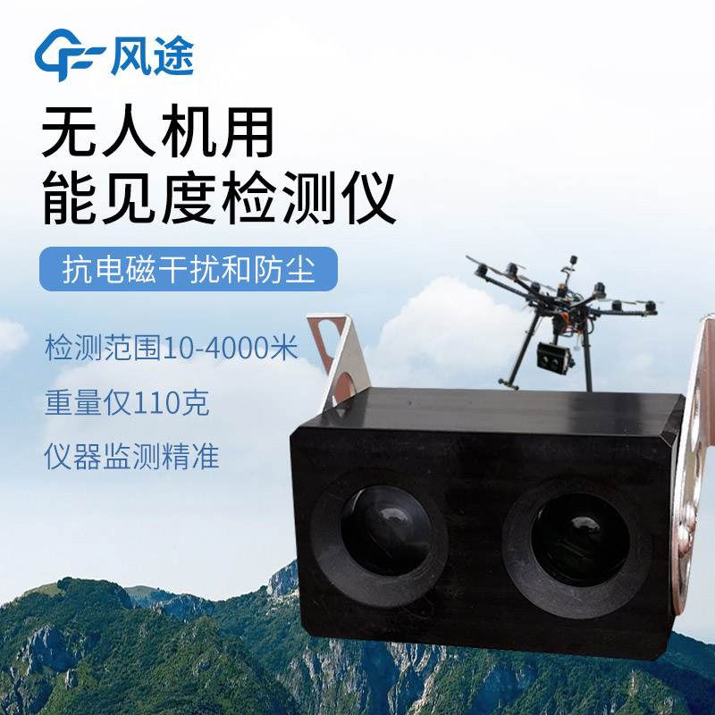
The Uav visibility meter (model FT-WJN4), as an environmental monitoring device specially designed for drones, fully considers the carrying characteristics of drones in its design. The overall structure of the device is compact, and its weight has been optimized, which will not significantly affect the load balance and endurance of the drone. The shell is made of weather-resistant materials, which can adapt to the climatic conditions of different regions. It can maintain stable working conditions in high temperature, low temperature or high humidity environments.
This detector works based on the principle of backscattering. The core is to capture the backscattering signals of the light beam by particles in the atmosphere by emitting light beams of specific wavelengths. By analyzing the intensity and characteristics of these signals, the device can quickly determine the visibility conditions of the current environment, with a detection range of up to 4 kilometers, which can meet the conventional flight needs of low-altitude and medium-altitude drones.
Compared with traditional ground-based visibility detection equipment, the advantage of FT-WJN4 lies in that it can perform mobile monitoring with drones, realizing dynamic perception of visibility in specific airspace. This mobility allows drones to autonomously avoid areas with poor visibility, reducing flight risks caused by sudden environmental changes. The data output interface of the device is standardized, which is compatible with the flight control systems of mainstream drones, facilitating integration and use.
A Lake Water Level Monitoring Station is a facility designed for the automated measurement of key parameters such as lake water level, flow velocity, flow rate, and water quality. Through continuous data collection and analysis, it provides a scientific basis for water resource management, flood war...
With the booming development of ecotourism, scenic weather stations have become common devices in major tourist attractions and ecological parks (such as artificial wetlands, ecological parks, botanical gardens, etc.). It is dedicated to the all - day automatic online collection of air cleanliness i...
Agricultural production is closely related to weather changes, and weather conditions play a decisive role in the growth, development, and final yield of crops. Torrential rains may trigger floods, submerge farmland, and damage crops. Droughts, on the other hand, can lead to insufficient soil moistu...
As a device widely used in fields such as water conservancy monitoring, environmental governance, and engineering construction, a flow meter can monitor water flow velocity data in real time with high accuracy, providing a scientific basis for decision-making. Currently, mainstream flow meters on th...


 Skype
Skype
 whatsapp
 mail
mail