Tianqiong Sensor IOT Technology Co., Ltd
Sales Manager:Ms. Emily Wang
Cel,Whatsapp,Wechat:+86 15898932201
Email:info@fengtutec.com
Add:No. 155 Optoelectronic Industry Accelerator, Gaoxin District, Weifang, Shandong, China


Sales Manager:Ms. Emily Wang
Cel,Whatsapp,Wechat:+86 15898932201
Email:info@fengtutec.com
Add:No. 155 Optoelectronic Industry Accelerator, Gaoxin District, Weifang, Shandong, China
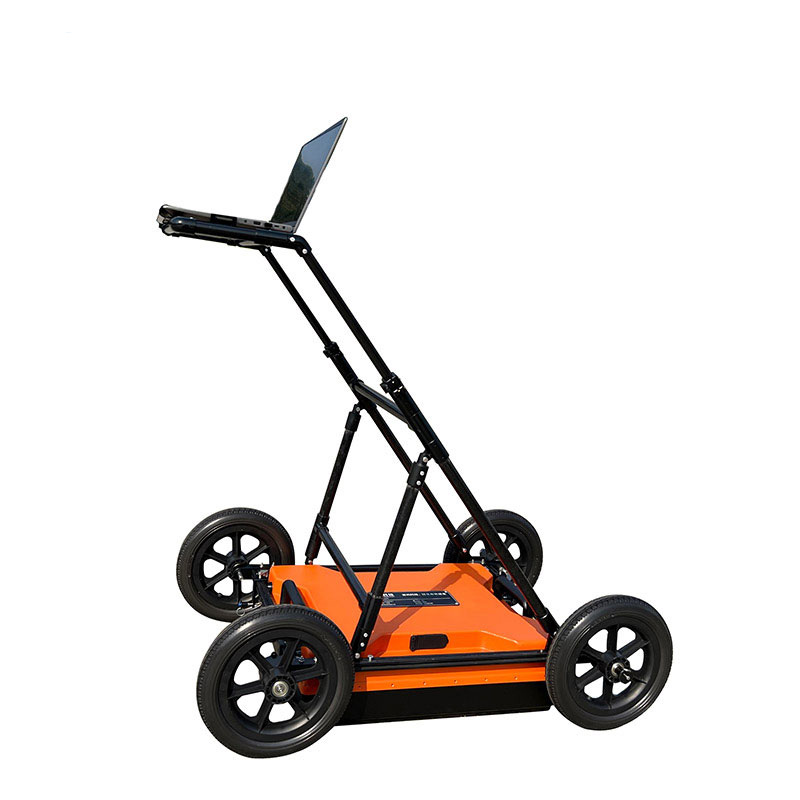
Model:FT-DZLD1
Brand:tianqiong
1.Uses of Ground Penetrating Radar
Ground Penetrating Radar is a geophysical method that uses radar pulses to image the subsurface and is used to analyze subsurface conditions at a given site.It is suitable for geological disaster assessment and governance, engineering exploration and design related projects; engineering survey, municipal pipelines, road and bridges, tunnel inspection and other fields, and is used to detect or identify metal or non-metal target information within a certain underground depth.The specific classification is as follows:
Geological disaster assessment: used to identify geological information such as holes, detachment, and broken zones in underground space;
Engineering survey: used to find information on underground abnormalities such as karst, collapse, crushing belts, etc.in the engineering area;
Municipal pipeline: used to find out the distribution of underground metal or non-metal pipelines during urban construction;
Road and bridge: used to investigate poor geological bodies during the identification of roads or bridge location selection;
Tunnel detection: used for tunnel advance forecasting, detection of tunnel construction quality, etc.;
2.Ground Penetrating Radar product features
This product adopts the industry-leading integrated design of host and antenna, with small size, light weight and low power consumption;
The host and computer are wirelessly connected, which is convenient to operate;
Realize real-time data collection and display;
The software interface is simple, easy to operate and quick to get started;
Multi-band antennas are optional and have a wide range of applications;
The analysis software is simple to operate and the results are accurate to interpret;
High detection accuracy and accurate positioning;
Built-in ultra-large capacity battery, long battery life;
Ergonomic structural design, simple, durable and easy to operate, is very suitable for outdoor mobile working environments.
3.Ground Penetrating Radar complies with the specifications
"Geophysical Exploration Procedures for Hydropower and Water Conservancy Engineering DL/T 5010-2005"
"Petrophy exploration procedures for water conservancy and hydropower engineering SL326-2005"
"Technical Regulations for Geophysical Exploration of Electric Power Engineering DL/T 5159-2012"
"Underwater Engineering Geophysical Exploration Procedure DB34/T 2209-2014"
"Highway cross-section flaw detection and structural layer thickness geological radar JT/T 940-2014"
"City Engineering Geophysical Detection Standard CJJ/T 7-2017"
"Technical Regulations on Urban Underground Pipeline Detection CJJ 61-2017"
"Radar Method Inspection Construction Engineering Quality Technical Regulations DGJ 32-TJ79-2009"
"Technical Regulations on Advance Geological Forecasting of Railway Tunnels Q/CR 9217-2015"
"Technical Standard for Comprehensive Detection and Risk Assessment of Urban Underground Diseases"
"Highway Engineering Geophysical Exploration Procedure JTGT 3222—2020"
4.Ground Penetrating Radar performance parameters
| Host | Antenna type | Single shielded antenna |
| Antenna frequency | 200MHz | |
| Sampling frequency | 0.2-100GHz adjustable | |
| Time window range | 1ns~20000ns, continuously adjustable | |
| Number of sampling points | 32~32767 sample points/scan, optional | |
| Scan rate | 200 lines/second | |
| A/D conversion | 18bit | |
| Continuous working hours | ≥8 hours | |
| Power consumption of the whole machine | <16 W | |
| Signal-to-noise ratio | Better than 120dB | |
| Collection speed | > 60 km/h @ 5 cm Horizontal sampling spacing (channel spacing) | |
| Minimum sampling interval | <10ps | |
| Measurement method | Three measurement methods: point-by-point measurement, distance-trigger measurement, and continuous measurement | |
| Display method | Pseudo-color diagram, stacked waveform or grayscale diagram | |
| Operating temperature | -30℃~+70℃ | |
| Operating voltage | 10-15V DC | |
| Wireless data transmission distance | More than 50 m | |
| Wired communication | Ethernet, 100Mbps | |
| weight | <8 KG |
In an era where technological waves continue to surge and innovative achievements emerge endlessly, the public's environmental awareness has grown increasingly sophisticated, and their concern for ambient air quality has reached an unprecedented level. In the fast-paced modern life, as the inter...
The FT-WQX6 micro weather sensor is a highly integrated device that combines multiple meteorological parameter measurement functions. Its key feature is the integration of six basic meteorological parameters—ambient temperature, relative humidity, wind speed, wind direction, atmospheric pressure, a...
As the name suggests, an air quality sensor monitors carbon monoxide (CO), sulfur dioxide (SO₂), nitrogen dioxide (NO₂), and ozone (O₃). CO mainly comes from incomplete combustion of fuels, such as automobile exhaust and industrial waste gas emissions. SO₂ is mostly produced by the combustion of...
In traditional cognition, agricultural production has often "relied on the weather", and weather changes have a huge impact on crop growth. Especially during the Sanfu days (the peak summer heat period), extreme weather such as high temperatures, high humidity, and heavy rainfall occurs fr...


 Get a Free Quote
 Skype
Skype
 whatsapp
 mail
mail