Tianqiong Sensor IOT Technology Co., Ltd
Sales Manager:Ms. Emily Wang
Cel,Whatsapp,Wechat:+86 15898932201
Email:info@fengtutec.com
Add:No. 155 Optoelectronic Industry Accelerator, Gaoxin District, Weifang, Shandong, China


Sales Manager:Ms. Emily Wang
Cel,Whatsapp,Wechat:+86 15898932201
Email:info@fengtutec.com
Add:No. 155 Optoelectronic Industry Accelerator, Gaoxin District, Weifang, Shandong, China
Model:FT-DZ1
Brand:tianqiong
1.Geological disaster monitoring background
Geological disaster monitoring combines geological disaster monitoring with early warning, and realizes real-time and effective monitoring of various instrument data.Geological disasters come from catastrophic damage to the geological environment by natural and man-made geological effects, mainly including collapses, landslides, mudslides, ground collapses and ground cracks.my country has complex and diverse geological disasters and frequent disasters, making it one of the most serious geological disasters in the world.In recent years, research on landslide and mudslide disasters has been the focus of industry research.In order to enhance the awareness of disaster prevention and reduction in the whole society, reduce casualties, maintain social stability and normal production and living order, improve people's quality of life, promote the economic construction in areas with serious geological disasters and the comprehensive development of various social undertakings, and enable the people to live and work in peace and contentment, it has become an urgent task to do a good job in geological disaster warning and forecasting.
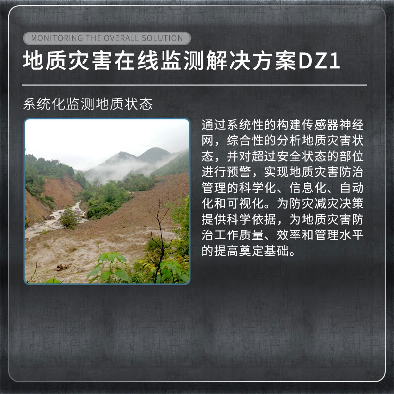
2.Overview of Geological disaster monitoring system
As a pioneer in industry monitoring, our company is the first to combine structural health monitoring with Internet of Things, cloud computing and other technologies.By systematically building sensor neural networks, comprehensively analyzing geological disaster status, and early warning of parts that exceed the safety status, so as to achieve scientific, informatized, automated and visualization of geological disaster prevention and control management.Provide scientific basis for disaster prevention and mitigation decisions, and lay the foundation for improving the quality, efficiency and management level of geological disaster prevention and control work.
3.List of Geological Disaster Monitoring Monitoring Projects
| Monitoring items | Device name |
| Surface displacement monitoring | Integrated GNSS monitoring system |
| Crack monitoring | Integrated surface displacement monitoring system |
| Deep displacement monitoring | Integrated deep displacement monitoring system |
| Groundwater level monitoring | Integrated pore water pressure monitoring system |
| Soil moisture content | Integrated soil temperature and humidity monitoring system |
| Rainfall | Integrated rainfall monitoring system |
| Video surveillance | Integrated video surveillance system |
| Mud level | Sludge level monitor |
4.Geological disaster monitoring basis
"Technical Specifications for Geological Disaster Monitoring DB11∕T 1677-2019"
"Geological Disaster Control Engineering Construction Safety Monitoring Specification T∕CAGHP 044-2018"
"Specifications on Monitoring of Collapse, Landslide and Mudslides"
"Technical Specifications for Groundwater Environmental Monitoring HJ/T164-2004"
"Geological Disaster Prevention and Control Engineering Survey Standard DB50∕143-2003"
5.Geological disaster monitoring implementation function
1.Through the automated monitoring platform, help management units realize geological information security monitoring and process management, and no longer be affected by the weather.Once an early warning occurs at any location on the scene, you can grasp the on-site situation through video monitoring, and take different alarm methods according to the warning level, and take emergency plan measures in a timely manner in combination with the relevant responsible units to evacuate the crowds, transfer in a timely manner to reduce accidents and disasters.
2.Achieve multi-level early warning and alarm mechanism from provinces, cities, counties and townships, provide emergency plans after early warning, and realize integrated disaster monitoring, early warning and response.Real-time long-term automated monitoring to prevent major landslides and mudslides and other geological disasters, reduce economic losses, and maintain social stability.
The River Flow Monitoring System is mainly used for remotely grasping the real-time hydrological conditions of various water areas, including natural rivers, artificial canals, and landscape watercourses. It assists relevant authorities in promptly recording the dynamic changes of river water source...
In the water conservancy and water services industry, water regime monitoring is a fundamental task. Especially during summer when natural disasters occur frequently, monitoring enables disaster prediction and provides data support for formulating flood prevention and relief plans. With the applicat...
The 4G high-precision handheld 6-element weather station is a portable and easy-to-operate mobile meteorological observation instrument. It can monitor six meteorological elements, supports 4G data upload, and is suitable for various mobile meteorological observation scenarios....
weather monitoring system is an unattended meteorological data acquisition system that uses ultrasonic principles to measure wind speed and direction. This system integrates data acquisition, storage, and transmission functions, featuring a compact structure and easy installation....


 Get a Free Quote
 Skype
Skype
 whatsapp
 mail
mail