Tianqiong Sensor IOT Technology Co., Ltd
Sales Manager:Ms. Emily Wang
Cel,Whatsapp,Wechat:+86 15898932201
Email:info@fengtutec.com
Add:No. 155 Optoelectronic Industry Accelerator, Gaoxin District, Weifang, Shandong, China


Sales Manager:Ms. Emily Wang
Cel,Whatsapp,Wechat:+86 15898932201
Email:info@fengtutec.com
Add:No. 155 Optoelectronic Industry Accelerator, Gaoxin District, Weifang, Shandong, China
time:2025-06-27 09:03:13 source:Weather Station viewed:471 time
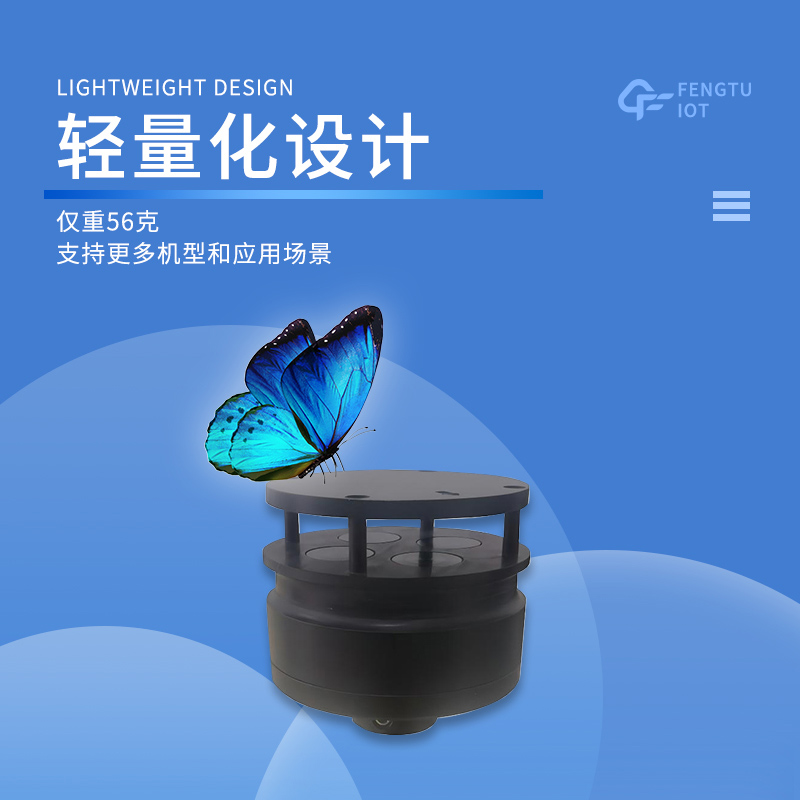
The Anemometer for Drones FT-F1 is specially designed for low-altitude wind measurement by unmanned aerial vehicles (UAVs). With high precision, stability, and efficiency, it provides accurate data for meteorological research, agricultural and forestry monitoring, environmental surveying, and other applications.
Ultrasonic Wind Measurement Technology
FT-F1 adopts ultrasonic wind measurement technology, calculating wind speed and direction by measuring the time difference of ultrasonic waves propagating in the air. This non-mechanical measurement method avoids the accuracy degradation and failure issues caused by mechanical wear in traditional mechanical sensors, enhancing the instrument's service life and reliability. The core components of the instrument undergo strict screening and calibration, enabling stable operation in extreme temperature environments ranging from -40°C to 85°C. It adapts to complex climatic conditions such as deserts, plateaus, and coastal areas.
High-Precision Measurement Capabilities
Wind Speed: Measurement range of 0.3m/s to 60m/s with an accuracy of ±0.1m/s.
Wind Direction: Measurement range of 0° to 360° with an accuracy of ±3°.
Such high-precision data collection capabilities meet the fine-grained measurement requirements in low-altitude complex airflow environments. Equipped with a high-speed data processing chip, the instrument achieves a data refresh frequency of 10 times per second, real-time detecting dynamic changes in wind speed and direction. This provides timely and accurate data support for UAV flight safety assessment and mission planning.
Applications in Diverse Scenarios
Meteorological Emergency Monitoring: UAVs equipped with this instrument can quickly reach disaster sites to obtain real-time wind speed and direction data in areas difficult to cover by ground weather stations, providing key data for disaster early warning and rescue decision-making.
Agricultural and Forestry Plant Protection Operations: Accurate wind speed and direction data help optimize UAV spraying paths, reduce pesticide drift, and improve operation efficiency and effectiveness.
Seamless Integration and Efficient Operation
FT-F1 supports multiple communication protocols, enabling seamless docking with UAV flight control systems and ground data platforms for real-time data transmission and analysis.
The instrument’s efficiency is also reflected in its convenient installation and operation:
Lightweight Design: Weighing only 56g, it does not affect the UAV’s payload or battery life.
Plug-and-Play Interface: No complex debugging is required, allowing rapid deployment. It is also dustproof and waterproof.
Crop growth monitoring refers to the dynamic observation of crop seedling status, growth conditions and their changes, which is related to the adjustment of cultivation measures. The adoption of rapid and non-destructive monitoring methods can not only reflect the changes in crop yield (whether abun...
The Portable Weather Station, with its highly integrated and user - friendly design, has become a common device in fields such as outdoor activities, emergency response, and scientific research expeditions. It integrates a variety of high - precision sensors for temperature, humidity, wind speed, wi...
The FT-YC03 Online Dust Monitoring System is an intelligent monitoring device that integrates multiple sensing and transmission technologies, designed for monitoring dust and noise pollution. It is widely used in environmental supervision and other fields.In the process of urbanization and ind...
All - in - One Weather Sensors represent a significant technological update in the field of modern meteorological monitoring. Through a highly integrated design, it combines traditional discrete measurement modules into a single device, enabling the synchronous collection of all - element meteorolog...


 Skype
Skype
 whatsapp
 mail
mail